Total Pageviews

Friday, November 18, 2016

A tiny town, Chugwater Wyoming means a mini blog.

The longest running old fashioned soda fountain in Wyoming is located in Chugwater, (population 214). 

It was cool to see the working fountain.

Bryan checking out the merchandise , it was part museum, part gift shop.

We loved Laura the solo employee.  She told us she lived "out in the middle of nowhere".  She enjoyed coming into the 'city' to work.

Built in 1914 the space was once a pharmacy.

The chili that won the annual contest.  It was good! 

A marker where the stage coach used to stop.

The name Chugwater came from running buffalo off the nearby cliffs back in the olden days.  Sad to report that evidently  the buffalo made a chugging sound when they hit bottom.  YIKES!!!  Interstate 25 is the major north/south route on the eastern side of the rocky mountains.  There is still PLENTY of room in the United States!  We have seen so much open country in the last five months.  It is a good feeling.  America is truly a beautiful country.  Thanks for following us!  M & B

Saturday, November 5, 2016

Battle of Little Big Horn Montana


Three of Custer's personal outfits.  He was what could be called today a metrosexual.  He was more decked out than the average military man in 1870's.  On the right is his buckskin outfit. He styled his long curly hair with cinnamon oil. 

View of Last Stand Hill from the museum. The hilltop is where Custer and his men were killed.
From the hilltop.  The markers are where members of the 7th Calvary fell.


220 men are buried under the monument.
Sioux, Lakota, Cheyenne and Crow Warriors are buried here with beautiful brown marble headstones. Sitting Bull and Crazy Horse fought and prevailed here.  Native losses were minimal.
Well organized information is found everywhere in the area.  The trees in the background are along the Big Horn River.


The marker with the black is where Gen. Custer was killed.  The green area in the background is a national cemetery.
 Two of Custer's brothers died here. Boston Custer, civilian, marker is the one in front.

Many tribes fought in the battle.  Their cause was just.  A huge land grant treaty was given to them in South Dakota.  When gold was found there the U.S. government took the land back.  This is the monument the tribes erected.


Native warriors gave their stories of what happened in the battle.  One said that just before Gen. Custer was killed his face went whiter than they thought possible.  Many of the soldiers shot each other rather than suffering from a live scalping and the like.  


Native American replica teepee's.
These beautiful moccasins are for sale at the nearby gift shop.  The adult ones sell for around 500 dollars.
The Crow nation owns most of the land around the battleground and run the gift shop.
We had a picnic and enjoyed a spring like day, amazing weather for November 5th in Montana.  Happy Birthday Angelique!

Monday, October 17, 2016

DEATH VALLEY CALIFORNIA International HOT SPOT

We stayed 5 days in Death Valley.  It was grand and beautiful.  One surprise was that 80-90% of tourists there were from foreign countries. We heard Spanish, French, Japanese, German, Chinese, Italian and more.  A lot of tour buses were coming out from Las Vegas.
One million people visit Death Valley every year.  This is Artists Palette.  A three mile side trip of multi colored hills.
The Devil owns property here.  This is the Devil's Cornfield. There is Dante's view and the Devil's golf course too.
The beautiful Panamint Valley, west of Death Valley.
Mesquite Sand Dunes near Stovepipe Wells.
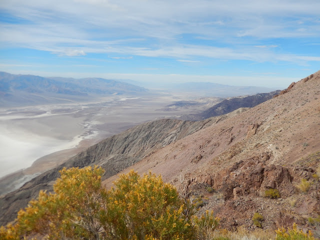
Dante's View.  Elevation 5,475 feet above sea level. Looking into the salt flats in Bad Water Basin, -282 feet below sea level.
The Devil's Golf course.
Tons of Borax was mined in Death Valley.  Who remembers washing their hands in Boraxo? I do.

Our rig at Stovepipe Wells. Very happy to have electricity. The air conditioner worked overtime.   The hottest day we had was 104 degrees.  Humidity was practically non existent.

D.V. R.R. locomotive on display at the Borax Museum, Panamint Springs.
If you can spot the  tiny white slash two thirds up the mountainside and above the white/gray rv?  That is sea level.
Many old relics of the west are kept out back of the free Borax Museum.
Two guys beating the heat while walking the Bad Water salt flats.  The water there isn't bad it is just very salty.
Being  below sea level, plus the high mountains surrounding the valley, equals extreme heat.  Death Valley is officially the hottest place on Earth.  The record high temperature is 134 degrees.
6 people had heart attacks so far this year while visiting D.V. This is not a place for foolish types.   Landmarks   look  much closer than they actually are.  They stress always carrying water and finishing a hike before 10 am. 
Bryan at the Furnace Creek visitors center.  Still pretty hot for early October and it wasn't lunch time yet.  190 feet below sea level.

Dante's View looking north.  It was 30 degrees cooler up here.
Cannot imagine working hard in a mine or even crossing the valley on foot.  Water is king here.   We were bummed when moon was too bright to see the stars.  Lesson learned - visit when there is no moon.   
Between Death Valley and Las Vegas.  The Area 51 Alien Center.

Thanks for viewing the blog.  The pictures don't really capture how awe inspiring and beautiful it is.  We met a young couple from Rome that were here on their honeymoon.  It made me feel good that so many fly thousands of miles to see our country.   It was a nice thing to be able to take the time to really explore the area.  After 4 months on the road, 
 I have to agree with what they say.....The West is the Best!  Love, Mary & Bryan

Saturday, October 15, 2016

Lone Pine Movie Museum- Hollywood hangs out here!

These are the Alabama hills.  They are part of the Eastern Sierra Nevada Mts. and are located a short way west of and behind the small town of Lone Pine, California along highway 395.  Approx. 600 movies have been filmed here.

Belongings of Bryan's favorite cowboy star Randolph Scott.

Does this place looked familiar? It should.  Some of the movies and TV made here?  Star Wars, Iron Man, Star Trek, Around the World in 80 Days, Chaplin, Django Unchained, Gladiator, How the West Was Won, Lone Ranger, Hopalong Cassidy and Lost Horizon....there are too many to list.

A stage coach seen in many productions.

Steve McQueen on location in the Alabama Hills.  He is sitting on top of the ladder. 

A commonly used film projector when we were kids.

Incredible to see two costumes worn by John Wayne.  On the right is from the movie THE SHOOTIST.  Fake blood can be seen on his left chest area.


Boots that were worn by Randolph Scott.


An old RKO filming truck.

Costume and props from Iron Man. This is what Robert Downy Jr. wore in the opening scene.

The museum in Lone Pine has so many interesting things. Who knows what famous butts sat here?!

Photo of RD jr in Iron Man


There is a large Lone Ranger collection.

Kids today probably don't know ol' Hopalong!! There is a huge Hopalong collection among others like Tom Mix, Gene Autry and Roy Rodgers and Dale Evans.


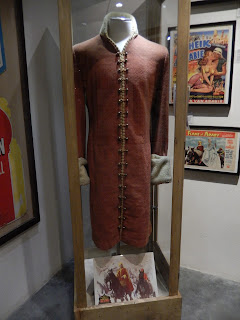
Montgomery Clift costume.

From Gunga Din.
M

Humphrey Bogart drove this car around back in the hills.  Sorry but I have forgotten the name of the movie.

Russell Crowe wore this outfit in THE GLADIATOR

From the movie THE BORDER LEGION

Mt Whitney is in the center of the posts, on the far left is Lone Pine Peak. This is as close as we got to the hills.

I really had to talk Bryan into stopping here.  Do you know guys that focus on driving from point A to point B with determination and grit?  Even when you are retired and have no real calendar?  We had a great time exploring the area.  Sure makes life more fun and interesting (and being right about stopping never gets old).  Next stop: DEATH VALLEY